

More hot weather is expected over the weekend, but we will see a brief break in the humidity and rain chances. Next week looks steamy again with occasional rain expected.
For tonight we'll see mostly cloudy skies. Temperatures will fall back into the mid 70s.
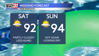
Expect a mix of clouds and sunshine Saturday. Temperatures will warm into the low 90s. Sunday looks slightly hotter, but still quiet, with partly cloudy conditions and afternoon highs in the mid 90s.
Humidity and rain chances return starting on Monday. Shower and storm coverage will pick up Tuesday and Wednesday as some tropical moisture associated with the remnants of Hurricane Beryl passes through the area. Rain chances will start to trail off later in the week.
Temperatures most of next week look seasonably hot, but nothing too extreme. Highs will mostly run in the upper 80s to low 90s with overnight lows in the 70s.
TONIGHT: Mostly cloudy skies. Lows in the middle 70s, Wind: NW 5 mph.
SATURDAY: Partly cloudy skies. Highs in the low 90s. Wind: N 3-6 mph.