
WAAY 31 StormTracker Meteorologist Amber Kulick has a look at a chilly Sunday morning forecast along with next week's rain chances.

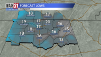
Patchy fog will be possible and that could turn into freezing fog so watch out on the roadways first thing Sunday.
More melting will take place so even the roads that were a little rough today will look better by Sunday afternoon. Sunday brings mostly sunny skies and high temperatures in the mid-40s.
Monday we will spend another day in the 40s before a dry cold front moves through that night and brings us another shot of some cold air for mid week.
By Friday highs are in the middle 50s and we will start to track our next weather maker. Highs into the weekend will remain in the upper 40s and lower 50s so what falls will be just rain but we will have to keep an eye on that following Monday for the risk of more wintry weather.. Keep checking back for the most updated information as we get closer.
SUNDAY: Mostly sunny, warmer. Highs in the lower 40s. Wind: S 5-10 mph.