

We'll wrap up the week with primarily dry weather, but rain chances will return over the weekend.
Clouds will fill back in overnight along with a few patches of fog developing. Temperatures will dip into the mid 60s.
Friday starts off with gray skies, but expect to see some sunshine by afternoon. There's only a slim chance for a shower. Temperatures will be unseasonably warm again for early November with afternoon highs in the upper 70s to near 80.
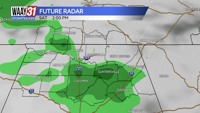
Showers will return to some parts of the area on Saturday ahead of slow moving cold front. Additional rain is likely to pass through on Sunday. Temperatures will remain mild for this time of year with afternoon highs in the low to mid 70s and morning lows in the 60s.
Rain tapers off early next week. Temperatures will cool slightly, especially at night. Afternoon highs will still be in the low 70s but morning lows will fall into the 50s.
Another cold front arrives midweek. Some limited rain is likely with it with temperatures cooling back closer to November averages. We'll see highs back down in the 60s and morning lows in the 40s before temperatures bounce back higher by next weekend.
TONIGHT: Partly cloudy. Lows in the mid-60s. Wind: NE 5-10 mph.
FRIDAY: Becoming partly cloudy by afternoon. Highs in the upper 70s. Wind: N 4-8 mph.