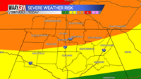


**31 ALERT DAY FOR TONIGHT**
A round of storms is likely during the overnight hours. Some storms could be severe with damaging wind the primary threat. A few tornadoes are also possible in the strongest storms.
Storms won't begin to impact the area until around or shortly after midnight when they arrive along the Alabama/Tennessee border. They'll gradually develop south and eastward across north Alabama through the late night hours. The threat of severe weather should be exiting northeast Alabama around sunrise.
Lows tonight will fall to around 70. The chance of rain is 80%.
Any lingering rain will wind down by mid-morning Monday. An isolated shower may pop-up later in the afternoon right along a cold front, but most areas will be dry. Temperatures will warm back into the mid 80s.
The rest of next week looks pleasant and dry in the wake of a cold front. Mornings will be comfortable in the 60s. Afternoon temperatures will run mainly in the low to mid 80s.
TONIGHT: Storms likely. Some could be severe. Lows near 70. Wind: S 10-15 mph.
TOMORROW: Rain early. Becoming partly cloudy with highs in the mid 80s. Wind: S becoming NW 10-15 mph.