
Changing how we diagnose mental illness
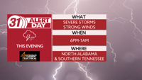
**TUESDAY EVENING IS A 31 ALERT DAY**
***WIND ADVISORY FROM 12PM TUESDAY UNTIL 3PM WEDNESDAY***
A 31 Alert Day, level 2/5 severe weather risk, and Wind Advisory are all in place today ahead of strong and potentially severe wind and storms this evening.

We will stay windy, cloudy but dry during much of the day today. Wind gusts this afternoon could reach up the 40mph. Later this afternoon, rain will start to develop in the Shoals and track east.
However, starting at about 6PM today, a line of potentially strong to severe storms will enter into the Shoals, it pushes towards I-65 by 8Pm, and into Sand Mountain by 9PM.
The greatest threat is up to 70mph wind gusts with a low end chance for tornadoes.
This line is coming with a cold front that plummets our temperatures tomorrow leaving Wednesday with a high in the low 50s. Thursday morning starts off near freezing but will rebound into the mid-50s for the high temperature of the day.
The good news is, Friday and this weekend bring high temperatures in the 60s with a mix of clouds and sun.
TUESDAY: Mostly cloudy, very wind. Storms arrive by evening. Some could be severe. Highs in the low 70s. Wind: SE 15-30 mph, gusts 35+.
TONIGHT: Strong to severe thunderstorms ending before midnight. Lows near 50. Wind gusts up to 70 mph.