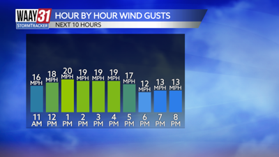

The cold front is moving through this afternoon and that will bring some breezy conditions and slightly cooler temperatures for the rest of the day. Highs this afternoon will make it into the middle to upper 60s.
From there, the temperature roller coaster becomes a reality yet again. Friday will reach a high temperature near 70, back down to the mid-60s and in the low 50s on Sunday before another warm-up to low 60s on Monday. The good news is we will stay dry over this period.
Next week we will keep an eye on the Tuesday Wednesday timeframe for the chance of stronger storms. A strong cold front will move through the area overnight Tuesday with a line of showers and storms ahead of it. We are still days out so we will have the timing and more details in the days to come.
TODAY: Clearing out, cooler. Highs in the mid-60s. Wind: NW 5-10 mph, gusts 20 mph.
TONIGHT: Clear skies. Lows in the mid-30s. Wind: Light NW.