


An extended stretch of seasonably hot and dry weather is ahead for the Tennessee Valley. No appreciable rain chances are showing up for least the next week.
Tonight brings clear and calm conditions. Temperatures will find their back into the low 70s by morning.
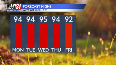
Expect a mostly sunny and hot start to the work week. Temperatures will heat into the low to mid 90s. It will be just humid enough to make it feel closer to 100.
Little day-to-day change in the weather is expected for the remainder of the week and into next weekend. Days will be typically hot and humid for August with afternoon highs in the low to mid 90s. Overnight lows will stay in the low 70s.
Tropical Storm Debby is forecast to reach hurricane strength tonight and make landfall in the Florida Big Bend area on Monday. No impacts are expected locally, but if you have a trip planned for next week from Florida to the Carolinas you'll want to check in with us for the latest tropical updates.
TONIGHT: Mostly clear. Lows in the low 70s. Wind: Light NE.
MONDAY: Mostly sunny. Highs in the low to mid 90s. Wind: N 5-10 mph.