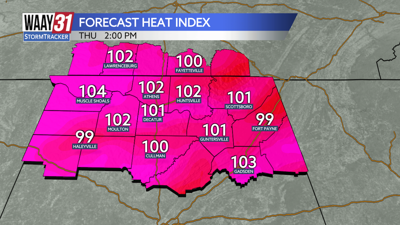


**HEAT ADVISORY IN EFFECT THROUGH 7 PM FRIDAY**
A potentially dangerous combination of heat and humidity will continue through the end of the week. "Feels like" temperatures between 105-109 will be with us tomorrow and into Friday, as well.
We'll stay warm and muggy, but otherwise quiet tonight. Temperatures will only drop into the mid to upper 70s.
The 4th of July will be typically hot and humid for this time of year. A few isolated showers and storms will pop up during the heat of the afternoon, but not everyone will see rain and those that do won't have a washout for the day. Any rain that pops up will be fading away in time for firework displays. Temperatures will be back in the mid 90s for highs.
Friday brings better rain chances. Temperatures will heat into the low 90s before showers and storms bring some cooling along with them.
The weekend is trending drier, although a few isolated showers and storms remain possible. Temperatures will continue to run in the low to mid 90s for highs.
Next week brings an uptick in daily rain chances. Temperatures will stay close to average for this time of year. Highs will be in the upper 80s to low 90s with overnight lows in the 70s.
TONIGHT: Partly cloudy skies. Lows in the upper 70s, Wind: SE 5 mph.
THURSDAY: Partly cloudy, hot and humid with a few afternoon showers and storms. Highs in the mid 90s. Wind: SE 6-12 mph.