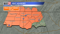


HEAT ADVISORY IN EFFECT THROUGH FRIDAY
Dangerous heat conditions are returning to the area for the rest of the week. The combination of temperatures well into the 90s along with very humid conditions will push the Heat Index above 105 the next few afternoons. If you have to work out in the heat, make sure you are taking plenty of breaks and staying hydrated. Outdoor pets need to have shade and a supply of cool water available.
For tonight we'll be partly cloudy, warm and muggy. Low temperatures will only fall back into the mid to upper 70s.
Wednesday will be a typically hot and humid July day. We'll be partly cloudy with just a slim afternoon shower chance. Temperatures will reach the mid 90s for highs.
The 4th of July brings more heat and humidity. Only a few isolated showers or storms are expected for your holiday plans. Temperatures will once again reach the mid 90s for highs.
As we head into the weekend expect to see better chances for showers and storms. Temperatures will ease some with the higher rain chances but we'll still reach the low 90s most days. Overnight lows will be well into the 70s.
Next week brings very few changes. We'll see a daily chance for a few showers or storms, otherwise expect seasonably hot and humid conditions with afternoon highs in the upper 80s to low 90s.
TONIGHT: Mostly clear. Lows in the upper 70s. Wind: SE 5 mph.
WEDNESDAY: Partly cloudy with a slim shower chance. Highs in the mid 90s. Wind: SE 6-12 mph.