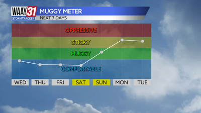


A drop in the humidity is on the way for the rest of the week and will likely last through the weekend. Rain chances will also dry up until early next week.
Clouds will hang around tonight, but any rain should end by early evening. Lows tonight will drop to the low 70s.
Wednesday starts with clouds, but expect to see sunshine by afternoon. Temperatures will drop slightly with afternoon highs near 90.
Thursday and Friday look mostly sunny and dry with tolerable humidity. Temperatures will remain hot with afternoon highs in the low to mid 90s. Mornings look pleasant with starts both days in the upper 60s to around 70.
Right now the weekend is looking very hot, but dry and not too humid. We'll be partly cloudy both Saturday and Sunday with afternoon highs in the upper 90s.
The humidity is back next week along with a gradual increase in daily chances for some showers and storms. Temperatures will remain hot in the mid to upper 90s.
TONIGHT: Mostly cloudy. Lows in the low 70s. Winds: W 5-10 mph.
WEDNESDAY: Decreasing clouds. Highs around 90. Wind: NW 4-8 mph.