

Dry weather will briefly settle in Thursday, but more rain and storm chances are back as we wrap up the week and start the weekend. The start of next week may bring the first 90 degree weather of the season.
For tonight we'll be mostly clear. Temperatures will dip into the low 60s.
We'll see partly to mostly sunny conditions Thursday. It will be the warmest day of the week with afternoon highs in the mid 80s.
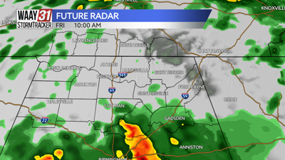
Friday will start off with some spots of rain in the morning. A few scattered showers and storms will develop for the afternoon. A strong storm is possible, but the overall severe weather risk remains low at this time. Temperatures will fall back into the 70s for highs.
Some showers will linger into Saturday morning, but the bulk of the weekend is trending dry. Temperatures will warm back into the mid to upper 80s by Sunday.
Next week starts with very likely the hottest weather of season so far with highs that could hit 90 for the first time this year.
TONIGHT: Mostly clear. Lows in the low 60s. Wind: NW 5 mph.
THURSDAY: Partly cloudy. Highs in the mid 80s. Wind: NW 4-8 mph.