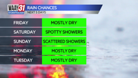

Today will feature a mix of clouds and sun with high temperatures sitting in the mid-90s. A small chance of a shower or two this afternoon but most of the area will stay dry and hot.
Saturday features more of the same but a better chance of seeing a pop-up afternoon shower or storm. Highs tomorrow will reach the lower to middle 90s.
Sunday will be another hot one with the chance once again for the summertime pop-up shower or storm in the afternoon hours. High temperatures again in the lower to middle 90s.
Monday-Wednesday are hot and mostly sunny with high temperatures in the low and mid-90s before scattered rain chances return in time for Independence Day on Thursday. It won't be a washout at any point when it rains next week so don't cancel any plans you have outdoors but make sure you have the Stormtracker weather app to keep up with the rain.
TODAY: Hot and humid, mix of clouds and sun. Highs in the mid-90s. Wind: SE 5-10 mph.
TONIGHT: Partly cloudy skies. Lows in the mid-70s. Wind: SE 5 mph.