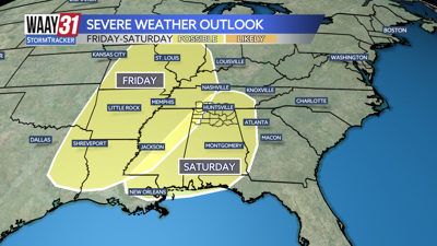


A few spots of rain will hang in tonight, but most should end by early Monday. We'll dry out for the first half of the work week, but look for more rain Thursday followed by storms and potential severe weather at the start of next weekend.
Scattered showers will linger into tonight. Lows will be in the mid 40s.
We'll dry out early on Monday with decreasing clouds expected. Temperatures will bounce back into the upper 60s for highs.
Tuesday and Wednesday look perfect and spring-like. We'll enjoy sunny skies both days with afternoon highs in the upper 70s.
Some rain is back on Thursday, but we'll make it through most of Friday on a dry note. Temperatures will close out the week in the 70s.
Stormy weather appears to be on the way for the first half of next weekend with severe weather a possibility. Keep checking back with us for updates on the timing and potential threats as we get closer.
TONIGHT: Isolated rain, staying cloudy. Lows in the mid-40s. Wind: NE 5-10 mph.
MONDAY: Drying out with decreasing clouds. Highs in the upper 60s. Wind: N 5-10 mph.