

The pattern remains an unsettled one with additional waves of rain and occasional storms ahead. By next week rain chances will ease slightly with temperatures inching back up closer to average highs for this time of year.
Tonight brings some spotty showers, but nothing too widespread. Temperatures will fall back into the low 70s.
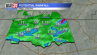
Another round of rain and storms is likely to pass through on Thursday. Heavy downpours are possible along with some gusty wind in the strongest storms. Temperatures will remain in the lower 80s for highs.
Rain chances will ease slightly Friday and into Saturday although a few spots of wet weather will impact some of the area. Temperatures will creep back into the mid to upper 80s with less rain around.
Sunday will likely bring an increased chance for showers and storms again with highs in the low to mid 80s.
Occasional showers and storms will hang on into next week. Temperatures will heat back up into the upper 80s to low 90s for highs heading into August.
TONIGHT: Isolated, light rain. Lows in the low 70s. Wind: Light S. Chance of rain: 20%.
THURSDAY: Another round of showers and storms. Highs in the low 80s. Wind: S 3-6 mph. Chance of rain: 50%.