

Clouds and some light showers will hang around the rest of the weekend and into early next week as a slow moving area of low pressure in the mid to upper atmosphere gradually moves away. Warmer and drier conditions are set to return for the second half of next week.
Clouds, fog and drizzle will hang around overnight. Temperatures will fall into the low 60s.
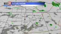
Sunday brings additional clouds and some showers at times. Temperatures will remain cooler than average for the end of September with highs in the mid 70s.
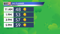
A few isolated spots of rain will hang around early next week, but look for a return to sunny and dry conditions by midweek. Temperatures will bounce back through the week going from the mid 70s on Monday to the mid 80s by the end of the week.
The tropics remain active with 2 named storms in the Atlantic. However, both will remain out over the water and not threaten the U.S. Later next week another tropical system could form in the Caribbean and may find it's way into the Gulf of Mexico. It's too soon to talk about where it could end up and what sort of impacts it would bring, but will definitely something to watch.
TONIGHT: Cloudy, with areas of drizzle. Lows in the lower 60s. Wind: SW 2-4 mph.
SUNDAY: Mostly cloudy with a few showers possible. Highs in the mid 70s. Wind: SW 3-6 mph.