
**FRIDAY IS A 31 ALERT FOR ACCUMULATING SNOW**
**WINTER STORM WARNING IN EFFECT 12 AM FRIDAY - 6 AM SATURDAY**
Today will be our last day before the winter storm arrives in the area. Highs will warm only to around 40. Clouds will move in this evening ahead of the system.
Snow will start falling overnight tonight. Snow starts in the Shoals around between 3-5am, the greater �鶹��ý/Athens/Decatur area between 4-6am, and Sand Mountain between 6-8am. Several inches of accumulation can be expected before Noon on Friday.
As we head into the late morning hours some of the snow south of the Tennessee River may begin to mix with or change over to sleet and/or freezing rain. Where surface temperatures climb above 32, a change to all rain is possible which will tend to lower the snow totals. All precipitation is expected to wind down by Friday evening.
Snow amounts of 3-6" look possible across the area with locally higher amounts possible particularly from the Shoals into southern Tennessee where precipitation will likely remain all in the form of snow. Where we mix in some additional precipitation types mainly south of the Tennessee River, snow amounts will be lower, on the order of 1-3". Any shifts in the track of the storm could result in either higher or lower amounts in any given area.
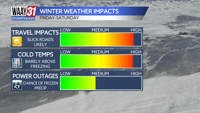
Travel is expected to become increasingly hazardous through the day Friday as the wintry precipitation adds up as temperatures hover very close to freezing. Many roads may become impassable Friday night as we all drop below freezing.
Isolated melting will take place on Saturday, though with the high temperature just barely above freezing, melting will be few and far between. Overnight, each night for the next 5 or so, refreeze will occur and lead to very difficult morning travel conditions. Sunday will be much warmer in the afternoon with sunny skies, leading to more melting throughout the Valley. Monday morning's commute could still present some challenges (due to the aforementioned overnight refreeze) but by Monday afternoon, most road conditions should be largely improved.
TODAY: Sunny, slightly warmer. Highs near 40. Wind: NE 5 mph.
TONIGHT: Snow starting west to east. Lows in the upper 20s. Wind: NE 5 mph.