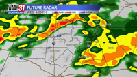

It's yet another day of rain in the Tennessee Valley. We saw anywhere from 1.5- nearly 3" of rain just yesterday, depending on where you call home. We could add an additional 1-3" to that total this afternoon. Widespread, heavy rain will stay with us most of the day.
High temperatures this afternoon will rise to the low and mid-50s. A few stronger storms possible this afternoon but the main threat would be some gusty winds, the overall threat is low.
Thursday and Friday bring cloudy but dry conditions. Thursday is much colder with a high temperature rising only to the mid-40s while Friday is slightly warmer with high temperatures rebounding to the mid-50s.
Saturday is warm during the day but brings scattered showers ahead of a cold front that will move through in the evening bringing a risk for strong to severe storms. We will work out the details on that in the coming days so keep checking back for updates. Behind that front much cooler air will return for the start of next week.
TODAY: Cloudy, rain and a few storms. Highs in the low 50s. Wind: SE 10-15 mph.
TONIGHT: Cloudy, isolated rain remains. Lows near 40. Wind: NW 5-10 mph.