


A strong ridge of high pressure building over the southeast U.S. will bring the warmest weather of the year so far the rest of the week with near record highs possible. It will also likely protect most of the area from stormy weather that will hit the middle of the country over the next few days.
The pattern will break down by the weekend allowing a cold front to move and bring rain and storm chances back up and temperatures back down.
Tonight will start off mostly clear, but look for clouds to fill in later tonight. Lows will be in the low 60s.
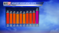
Wednesday starts with clouds, but expect at least partly cloudy conditions by afternoon. We'll be windy and warm with afternoon highs in the mid 80s. There's a very slim chance for a shower or storm to reach far NW Alabama late in the day.
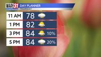
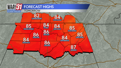
Thursday and Friday will bring more of the same. A mix of clouds and sun along with highs in the mid to upper 80s. Rain chances will stay slim with the best chance for any storms across the far NW corner of the state.
The warm and primarily dry weather will continue into Saturday, but expect to see rain and storms pick up later Saturday night and into Sunday as a cold front pushes into the area. Some strong storms are possible. After seeing highs in the low 80s Saturday will cool back to around 70 on Sunday.
Next week brings quiet but cooler weather. Highs early in the week will be in the 60s with morning lows in the 30s and 40s. A frost is looking possible a morning or 2 early next week.
TONIGHT: Becoming cloudy. Breezy. Lows in the low 60s. Wind: SE 5-10 mph, gusts 25 mph.
WEDNESDAY: Cloudy morning. Becoming partly cloudy by afternoon. Windy and very warm with highs in the mid 80s. Wind: S 15-25, gusts 30 mph.