

We're back to calm weather for now. A slow moving cold front will near the area around midweek but a strong ridge of high pressure over the southeast may keep most of us dry until the weekend. The warmest weather of 2025 so far is ahead for the second half of the week.
Skies will remain cloudy tonight. Temperatures will cool down into the low 40s.
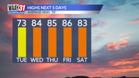
Clouds will break up through the day Tuesday with some sunshine returning. Temperatures will hit the low 70s for highs.
Wednesday looks very warm with temperatures climbing into the low to mid 80s under partly sunny skies. Some storms could reach the Shoals during the evening hours with a risk for some severe weather there.
Thursday and Friday continue the warm streak with highs in the mid 80s both days. Storms will get close, but could remain just to our north and west.
A cold front will finally get a push through the area over the weekend increasing our rain and storm chances. Right now Saturday night into Sunday look wettest. Severe weather is possible, but not a certainty at this time. Temperatures will still be in the 80s Saturday, but expect to cool back to around 70 on Sunday.
Next week starts off cooler with highs in the low 60s and the possibility of a late season frost early in the week.
TONIGHT: Cloudy. cooler. Lows in the low 40s. Wind: N5 mph.
TUESDAY: Partly cloudy and mild. Highs in the low 70s. Wind: E 3-6 mph.