

Spring-like conditions will continue into midweek with what could the warmest weather of the year so. Temperatures will ease back a little to wrap up the week, but we'll still be above average for late February. The forecast remains a mostly dry one until around the middle of next week.
Skies will stay mostly clear tonight. Lows will fall to around 40.
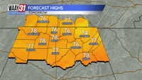
Look for a few clouds Wednesday, but also a fair amount of sunshine. Temperatures will top out in the mid 70s.
Clouds will roll in to start off Thursday ahead of a weak cold front. We might see a shower, but most spots will stay dry. Temperatures will pull back into the low to mid 60s.
We're back to sunshine Friday and Saturday with highs in the mid to upper 60s. Another dry cold front arrives into Sunday dropping our temperatures back into the 50s to close out the weekend.
Temperatures will warm back into the 60s next week with rain chances picking up again starting late on Tuesday.
TONIGHT: Clear skies, mild. Lows around 40. Wind: Light SE.
WEDNESDAY: Partly sunny. Highs in the mid 70s. Wind: SSW 6-12 mph.