


Very warm and dry conditions will continue through midweek. We will see rain chances return later into the week and last through the long holiday weekend, but it's not necessarily looking like a washout.
Skies will be mostly clear heading through tonight. Temperatures will settle back into the mid 60s.
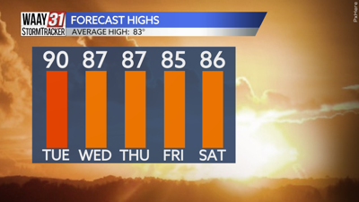
Look for another mostly sunny and quiet day Tuesday. Temperatures could reach 90 for the first time this year. An increase in clouds Wednesday will likely trim temperatures back into the upper 80s.
Isolated rain will be back on Thursday with showers and storms becoming more numerous starting Friday and continuing through the Memorial Day weekend. Very warm and humid conditions will continue with highs in the mid to upper 80s and morning lows not too far from 70.
TONIGHT: Mostly clear. Lows in the mid-60s. Wind: SSE 5 mph.
TUESDAY: Mostly sunny and almost hot. Highs near 90. Wind: S 5-10 mph.