


Brighter skies and warmer weather will return for the rest of the week. Rain chances will be drying up as well.
Clouds and some fog will fill back in tonight. Temperatures will drop back into the mid 60s.
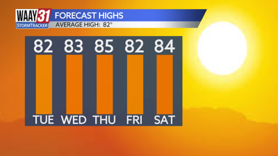
Clouds will break up through the day Tuesday. There is an outside shot at a stray shower, but most spots will remain dry. Temperatures will warm into the mid 80s.
Mostly sunny conditions are back for midweek with highs getting into the low to mid 80s.
Some clouds and slim shower chance are back on Friday with highs staying in the mid 80s.
Right now the weekend ahead looks pleasantly warm and quiet. We'll enjoy some sunshine and afternoon temperatures in the 80s.
The tropics remain active, primarily well out to sea in the Atlantic. Closer to home there is some possibility of a tropical system forming sometime in the next week in the NW Caribbean or southern Gulf. We'll be watching closely for anything that forms and what it could mean for the U.S.
TONIGHT: Cloudy. Lows in the mid-60s. Wind: N 5 mph.
TUESDAY: Clouds early, breaking up in the afternoon. Slim shower chance. Highs in the low-80s. Wind: N 4-8 mph.