


Storm chances are back by Sunday evening, but most of next week is looking pleasant and dry.
Tonight will be mainly clear and chilly. Lows will be in the mid 40s.
Much of the day Sunday looks quiet. We'll start off with sunshine in the morning, but look for some clouds on the increase into the afternoon. Temperatures will be warm with highs in the upper 70s.
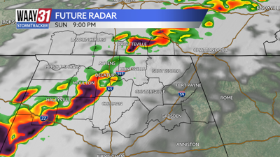
Showers and storms are expected heading into Sunday evening. A few strong to severe storms are possible, but widespread severe weather is not expected. The strongest storms will bring heavy rain and some gusty wind.
Dry weather is back to start off the work week. Monday looks slightly cooler with highs in the upper 60s. The rest of the week looks mild and dry with highs mostly in the 70s.
Some more rain and storms could be back again by next weekend.
TONIGHT: Clear skies. Lows in the mid 40s. Wind: SE 5 mph.
SUNDAY: Mostly sunny early with increasing clouds late. Highs in the upper 70s. Wind: S 10-20 mph.