

Happy Thanksgiving! Rain has moved out and colder air is in the process of moving in. We're expecting the coldest weather of the season through early next week with several nights of hard freezes ahead.
Today brings plenty of clouds and chilly conditions. Temperatures will primarily hold in the mid to upper 40s the rest of the day.
For tonight we'll begin to clear out. Temperatures will drop into the low to mid 30s.
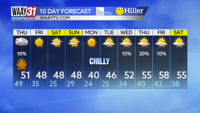
Friday we will see highs in the upper 40s with overnight lows into Saturday dropping into the 20s.
The chill continues this weekend, but we'll be otherwise quiet. Highs both Saturday and Sunday will only be in the upper 40s.
The cold weather will be with us for the start of next week so make sure you are protecting the 4 P's people, pets, plants, and pipes. We'll begin to warm back up to near average in the upper 50s by the middle of the week.
THURSDAY: Dry, cooler. Steady temperatures in the mid to upper 40s. Wind: NW 5-10 mph, gusts 20 mph.
TONIGHT: Clearing skies. Lows in the mid 30s. Wind: NW 3-6 mph.