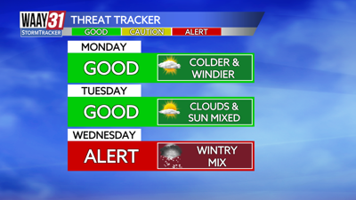
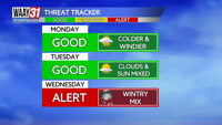

**31 ALERT DAY FOR TUESDAY NIGHT-WEDNESDAY MORNING**
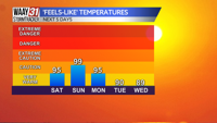
Temperatures sure are frigid yet again today. Morning temperatures are feeling like the low 20s, high temperatures this afternoon will feel like 40. We will keep a mix of clouds and sun all day with a breeze. Tuesday is not too different with yet another mix of clouds and sun and high temperatures feeling like the mid-40s.

Tuesday overnight through Wednesday early morning brings snow and a wintry mix to the Tennessee Valley. Snow will start in the Shoals around 11pm Tuesday and this mix will continue through about 10am Wednesday.
1-2" of snow are expected north of the Tennessee River with a rain and snow mix south of the River, just rain in our far southern counties.
Wednesday morning brings temperatures in the upper 20s with high temperatures barely above freezing, in the mid-30s Wednesday. Thursday and Friday mornings are arctic with temperatures in the low teens. Thursday afternoon features a high temperature in the upper 20s but Friday is much warmer with high temperatures in the upper 30s.
MONDAY: Breezy, am clouds, midday sun. Highs in the mid-40s. Wind: N 5-10 mph.
TONIGHT: Mostly clear skies. Lows in the upper 20s. Wind: NE 5 mph.