

Temperatures will stay chilly the rest of the weekend with another surge of cold air coming to start off next week. We'll see the coldest temperatures since January by Tuesday morning.
Some clouds will move in tonight, but we'll stay dry. We won't be as cold as last night, but temperatures will still fall into the upper 20s to around 30.
Sunday starts with some clouds, but look for sunshine to return during the afternoon. Temperatures will reach the low 50s before a reinforcing shot of chilly air begins to settle in.
The work week starts off sunny and dry. Another surge of cold air will come in on Monday and push temperatures to the lowest readings since January. Highs Monday will reach the mid 40s.
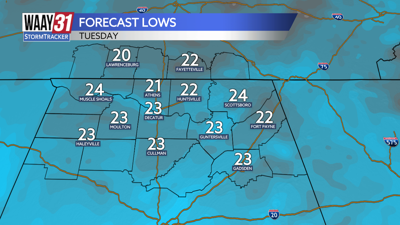
Tuesday will start off frigid with much of the area seeing temperatures in the upper teens to low 20s. We'll only warm into the low 40s despite plentiful sunshine through the day.
The chill will begin to moderate on Wednesday. After a start just below freezing we'll get back into the 50s by afternoon. A stray shower is possible, but most of us are looking dry. Thursday also brings another slim shower chance with temperatures remaining in the 50s.
Another push of chilly air will drive temperatures back down into the upper 40s to low 50s as we head into the weekend.
TONIGHT: Mostly cloudy. Lows in the upper 20s. Wind: Light S.
SUNDAY: AM clouds, PM sun. Highs in the low to mid 50s. Wind: Becoming NW 5-10 mph.