

**FROST ADVISORY FROM 3AM-8AM FRIDAY**
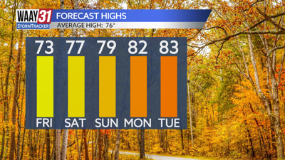
After several cold nights in a row, temperatures will start to bounce back over the weekend with above average warmth expected throughout next week. Rain is still a no-show for at least the next 10 days.
Tonight will be clear and cold again. A light frost is expected as temperatures drop into the mid to upper 30s.
Sunny skies are back Friday with temperatures warming into the low 70s.
The weekend looks pleasant and dry with plenty of sunshine and a gradual warming trend. Mornings will stay chilly in the 40s, but the afternoons will be comfortably warm in the upper 70s.
The warm up continues into next week with highs getting back into the 80s. Wednesday will be the warmest day of the week with highs in the mid 80s. Mornings will stay cool with overnight lows running a few degrees on either side of 50. More sunny and dry days are ahead.
TONIGHT: Clear skies, cold again. Lows in the upper 30s. Wind: Light NE.
FRIDAY: Mainly sunny and pleasant. Highs in the low 70s. Wind: SE 3-5 mph.