


A cold front arrives Thursday with not much fanfare, but we will cool off a little to wrap up the week. Next week brings a more active pattern with better chances for rain and storms around midweek.
Clouds will fill in tonight. Temperatures will drop back into the low 50s.
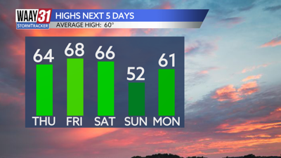
We'll start Thursday with overcast skies and maybe a stray shower. By afternoon look for a clear trend. Temperatures will fall back into the mid 60s for highs.
Sunshine is back Friday with afternoon highs close to 70. Temperatures will come down a little over the weekend with highs in the mid 60s Saturday and low 50s on Sunday. The weekend will remain otherwise quiet.
Next week brings another warm up with highs back around 70 by Tuesday. We'll be tracking increasing chances for showers and storms coming in later Tuesday night into Wednesday. Some severe weather will accompany this next weather maker to our west, but it's unclear at this time if any strong storms will move through north Alabama.
TONIGHT: Clouds move in. Lows in the low 50s. Wind: SW 5 mph.
THURSDAY: AM clouds followed by afternoon clearing. Highs in the mid 60s. Wind: NW 6-12 mph.