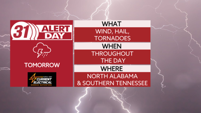


***SATURDAY IS A 31 ALERT DAY***
Now is the time to make sure you are prepared for tomorrow's 31 Alert Day that spans the entire day. Overnight temperatures will drop into the lower 60s. In the early hours of Saturday morning showers will start to develop and move into the Tennessee Valley. This could bring our first round of strong to severe storms.
The chance for severe weather will come in waves throughout the day on Saturday. In the late afternoon and evening, the risk for strong and severe storms will be higher, damaging winds, hail, and tornadoes some could be strong will all be possible.
The cold front will finally push through late Saturday into early morning Sunday and take the risk of severe weather with it.
Sunday brings pleasant, dry, sunny, and calm weather to the Valley with a high temperature in the mid-60s.
TONIGHT: Storms late. Lows in the mid-60s. Wind: SE 15-20 mph, gusts 25-30 mph.
SATURDAY: 31 Alert Day. Severe weather likely. Highs near 70. Wind: SE 15-20 mph, gusts 30 mph.