


An active pattern is ahead for the next week. Rain and wind will move through this evening followed by a turn to much colder weather for the week ahead. By the end of next week we'll be looking at the potential for accumulating wintry weather.
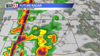
Tonight brings a swath of rain with a few embedded thunderstorms. The potential for severe weather looks low, but a strong storm could produce some locally high wind gusts. Non-thunderstorm winds will remain strong with occasional gusts between 30-40 mph.
Colder air moves in during the day Monday. Temperatures are likely to fall to near freezing by midday and stay there through the afternoon. We'll be mostly cloudy with a few snow showers or flurries possible. No accumulations are expected.
Tuesday through Thursday look cold, but quiet. Temperatures will mostly stay in the 30s for highs with overnight lows in the teens to low 20s.
An area of low pressure is expected to form and track near the Gulf coast by the end of the week. With cold air already entrenched across the area, that will set the stage for seeing a round of wintry precipitation across the area. Some accumulations of snow and ice are looking probable, although the exact track and strength of the low will ultimately determine just how much. Be sure to check back over the next few days as we nail down the details of this winter weather threat.
TONIGHT: Rain likely with a few storms. Windy. Lows in the mid 30s. Wind: S 15-25, gusts 30-40 mph.
MONDAY: Windy and colder with a few snow showers or flurries. Wind: NW 15-25 mph, gusts above 30 mph.